By Mike Busch
After seeing some photos and getting reports of sand building inside the East Jetty of Moriches Inlet, I hiked my way through Cupsoge Beach County Park Saturday afternoon at low tide to take a look.
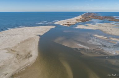
For reference the photo below, taken in late November, shows how the inlet normally looks.

Moriches Inlet, November 19th 2017
Moriches Inlet is well known for its shoaling but three consecutive Nor’easters have deposited so much sand on the inside of the inlet it looks more like a beach than a waterway. I would estimate that at low tide about 25% of the inlet between the jetties is dry land. The sand stretches from the far end of the east jetty all the way around to the backside of inlet. Many locals don’t remember it ever being so bad.
The Coast Guard has surveyed the area and is advising boaters to avoid the inlet. There are also reports that the channels leading to inlet have also shoaled up leading to a call for Federal help and emergency dredging.
Local fisherman and boaters are very concerned with the Spring boating and fishing season right around the corner.

Cupsogue Beach 3-13-18
The photos below were taken Saturday, March 17th.


More Images on Pages 2 and 3