By Mike Busch
Last summer, Sarah Gulick of the National Park Service reached out to me for some footage of Old Inlet for a project they were working on.
I was happy to help and over the next 6 months or so we picked out some different clips that might work.
I had no idea what else Sarah was working with but the final result is the most comprehensive video to date of what happened and what the future holds for the breach.
It is also covers many of the scientific projects based on the breach and Eastern Great South Bay and how it has become a great way for the Park Service to learn how to handle similar situations up and down the Eastern Seaboard.
The breach has in many ways become a huge science project with multiple studies monitoring water quality, sea grass restoration, and shellfish recovery.
I was happy to see about 10 of my video clips spread through the production but the real credit should go the the staff at the National Park Service and Fire Island National Seashore. As you will see below, they brought together scientists, biologists, geologists, oceanographers and volunteers from multiple institutions to do important work at the the breach.
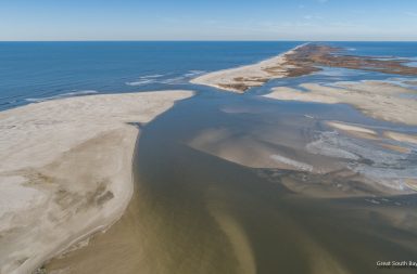
Below the video I included some images that show Old Inlet starting in October 2012 just before, during, and after Sandy. On pages 2 and 3 I have included some aerial images taken last year, to give an idea how much the inlet changes month to month.
You can watch the video full screen on the Fire Island National Seashore Facebook page and find out more information about the Old Inlet Wilderness Breach on the National Park Service / Fire Island National Seashore website.

Two Weeks Before Sandy

Waves Behind Pattersquash Gun Club 10-30-2012

December 2012

December 2012

December 2012

January 2013

March 2013

July 2013
More images on Page 2