The November 28 flight took place at 0930 EST, about 2 hours after low tide in the ocean and an hour before low tide in the Bay. As a result, many of the shoals of the flood delta were above water and easily visible in the oblique photo above. The track of the jet-ski visible in the photo shows that it followed the main channel and now goes north of the remains of Pelican Island, before heading off to the northwest. And the large shoal east of Pelican Island that has been building over several months, is now built up enough to be above water at low tide.
We missed a December flight because of the weather and holiday complications. In early January we had a substantial snow storm which caused the salinities in Bellport Bay to drop noticeably as the snow melted. Since then we have had a series of rain events totaling about 6” which have kept the salinities much lower than we’ve been used to since the breach opened. These low salinities are related to rain events rather than a partial closing of the breach because right now, beginning March, the salinities are back up to about 29 psu.
The breach looked very similar at the times of the January 27th and February 27th flights, both occurring during ebb and near low tide in the ocean. The figure below shows the latest mosaic from February showing the main features of the breach, flood and ebb deltas. The main message is that the channel through the breach has become more and more convoluted, a situation that has been building for the past year. This has led to the development of a sand island just north of the eastern shore in a location that was at one time the middle of the main channel. The channel into the Bay passes north of the Pelican Island remnants as it has for some time. In comparing the October mosaic above with the latest version, notice that the through-breach sand island that showed up in July, has disappeared. The entrance channel into the breach is about 75m wide which is a little smaller than it has been while the exit to the ocean continues to tail-off to the east.

Photo mosaic of the breach from the February 27, 2018 overflight at 9:15 EST | Dr. Flagg
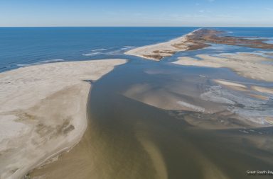
Another interesting thing is the development of the ebb shoal along the western shore. This has been going on for a long time but now there are several sand islands that are above water at low tide. The ebb shoal is formed by sand that has been exported from the breach. This sand can be thought of as sand that did not quite make through the breach and onto the flood delta. As a result, the sand was expelled from the breach and settled out just off shore as the currents slowed. The alongshore channel just inside the sand islands of the ebb shoal is referred to as a “marginal bypass channel”. The bypass referring to the littoral drift of sand from the east that passes just offshore of the ebb shoal. The tail of the ebb shoal ends near the old inlet where there has been some erosion. The area farther west including that around Bellport Beach is outside of the immediate impact of the breach as for the most part, the littoral drift of sand from the east passes around the ebb shoal.

Oblique photo of the breach and western shore from the February 27, 2018 flight showing the elongation of the ebb shoal

February 27th 2018 | Dr. Flagg
For more information, please visit Dr. Flagg’s website.