By Mike Busch 11-5-2021
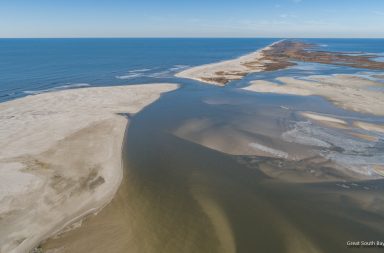
I checked out the Old Inlet Wilderness Breach on October 24th about two hours before high tide. I have been monitoring this breach for 7 years and this was about as narrow as I have seen it since it first opened during Sandy. Nobody knows when it will close but things are looking dire from my perspective. The eastern Great South Bay has had an incredible revitalization thanks to this new inlet and I fear that progress will quickly reverse when it closes. We had two Nor’easters last week so I hope to take advantage of the nice weather forecast to see how it may have changed in the next few days but you don’t have to wait.
As luck would have it, Dr. Charles Flagg of Stony Brook University just happened to post his first update since March on the breach yesterday. Dr. Flagg has been flying over the inlet and posting his research consistently for his Great South Bay Project Website. Besides aerial photos, Dr. Flagg has been monitoring salinity levels in Bellport Bay that give the best indication of how much fresh ocean water is mixing into the bay. As you will read in his report below, the latest data is not encouraging if you want the inlet to stay open.
Dr. Flagg gave me permission to reprint his report below. These photos were taken after the recent Nor’easters so they clearly had a big effect. If you compare these to my photos on pages 2 and 3 you can see a dramatic difference.
Breach Update, November 2021 Charles Flagg Stony Brook University
Below are two oblique photos of the breach taken November 3rd, by Rich Giannotti. Rich has been part of the breach monitoring effort from the very beginning and has provided much support and the occasional important photos of the breach. These latest photos taken near a spring low tide show an extensive ebb (offshore) delta that has developed over the past few months. Hints of its development have shown up in March (see John Vahey’s photos) and in some of the high altitude, ~4000 ft, photos taken earlier this year but Rich’s beautiful photos provide an update and much more detail. (The photos are up on the project website, http://po.msrc.sunysb.edu/GSB/.)
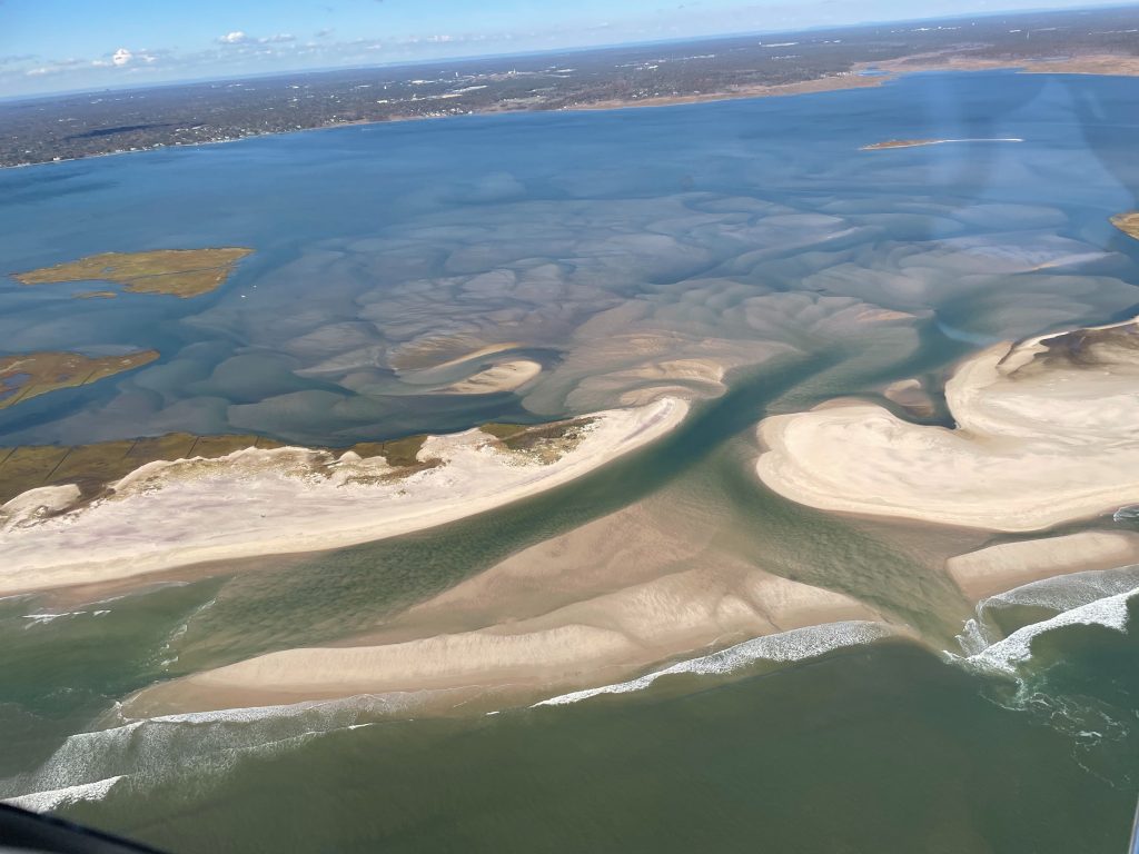
Figure 1, Oblique photo of the breach taken by Rich Giannotti November 3, 2021
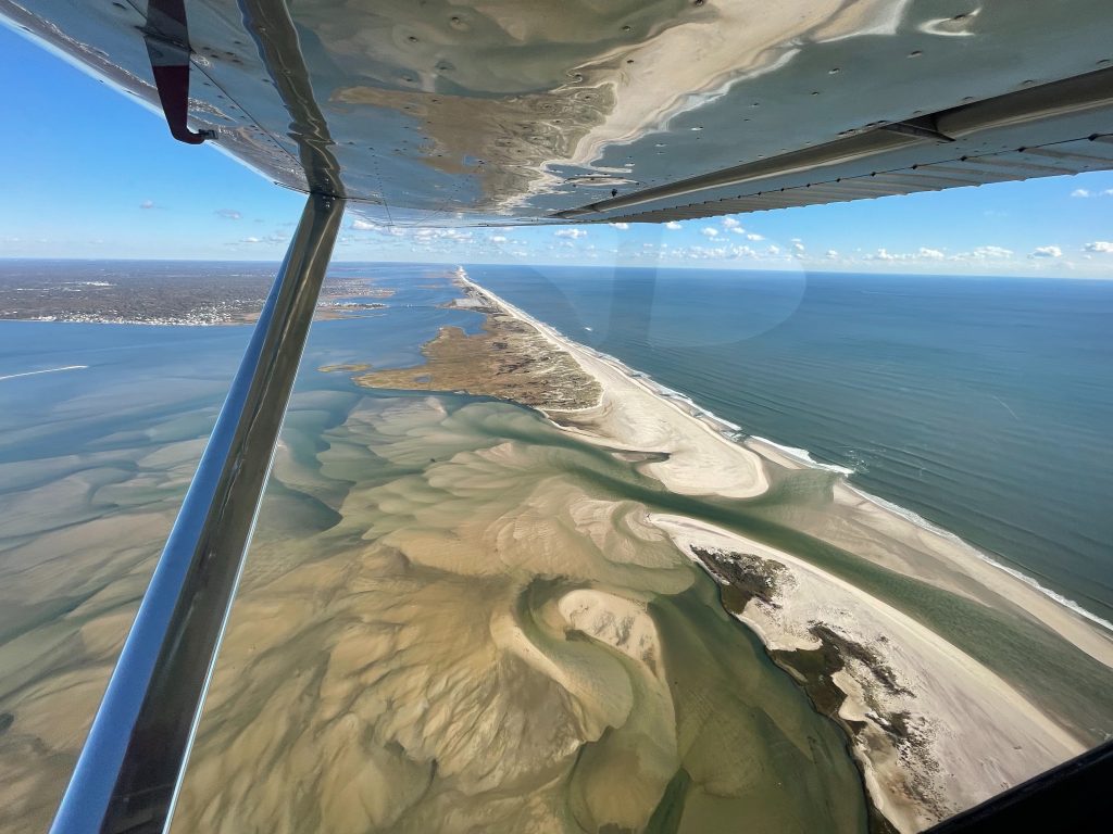
Figure 2, Oblique photo of the breach taken by Rich Giannotti November 3, 2021
So now the main exit channel closely follows the shore to the west with a lesser channel to the south and east. On the inshore side the main channel quickly runs into a shoal region and there is little indication for a clear channel to Bellport Bay. All this is evidence of progress toward closure, something we have been expecting for a long time and which is ultimately inevitable for a barrier island breach. In Figure 2 are the temperature and salinity records from the Bellport dock. The seasonal cooling of the bay is clear but the important information is contained in the salinity record. Recall that prior to the breach salinities in Bellport Bay were typically in the range of 24 to 25 psu while the ocean salinities south of Fire Island are in the range of 32 to 33 psu. Salinities at the Bellport dock are a good indication of the amount of ocean-bay exchange. Early in the history of the breach Bellport salinities were in typically around 29 psu often increasing to near oceanic values. The breach is now almost exactly 9 years old and over the past 5 years or so the salinities in the bay have slowly decreased with occasional increases to near ocean values as a result of nor’easters. And you can see those features in the salinity record from the last couple of months when we get a shot of ocean waters that last less than a week before the bay settles back to ever-decreasing salinities. Lately, the “default” salinities have been around 26.5 psu, they have been lower than this in the past year or so.
Clearly the breach is headed toward closure with all the attendant impacts on the Great South Bay. But it has lasted longer than expected and I have suggested imminent closure at times in the past couple of years which has not come to pass; so we will see.

Photos taken on October 24th on Pages 2 and 3