By Mike Busch
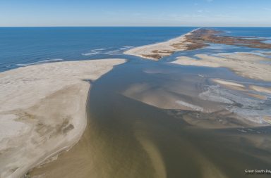
Conditions were perfect on Sunday morning with clear blue skies, very little wind, and excellent water clarity on the Great South Bay. In addition, there was an extremely low tide. exposing shoals and sand bars normally covered by water. Knowing this was a great chance to check out Old Inlet, I took a drone flight to see how things have changed over the winter.
One particular concern has been the dredging projects that were recently completed, moving sand from Moriches Bay and Moriches Inlet onto the Smith Point outer beach. Sand on Fire Island is constantly pushed around by wind and waves from east to west. My fear was this fresh sand would make its way to Old Inlet, which appears to be happening. As you will see in the video above and the photos below, the spit of sand on the east side of the inlet has grown and pushed westward toward the both the east side and another big deposit of sand near what is left of Pelican Island. While probably exaggerated by the low tide, the amount of sand that has built up inside the bay is hard to fathom.
I showed some of the photos to Dr. Charles Flagg of the Stony Brook University School of Marine and Atmospheric Sciences, who has been monitoring the inlet since it opened 6 years ago. Dr. Flagg thinks the inlet is in the process of closing but can not predict how long it will take. Dr. Flagg is monitoring the salinity levels at Bellport Dock and they are getting lower and lower, indicating less ocean water mixing in.
Dr. Flagg plans on another flight this week, we will follow-up any updates. You can check out a lot of his research over the past 6 years here: Great South Bay Project
Fire Island and Beyond has built up a big library of features regarding the Old Inlet Wilderness Breach, click here for 16 pages of content.


More Photos on Pages 2 and 3