By Mike Busch
I have been curious to see how Old Inlet may have changed over the winter but since I don’t have a plane my options have been limited.
I walked to the inlet in February and noticed some changes from sea level. Click here for the images and video from 2-20-17.
Click here for some older aerial images taken in August, 2013.
I tried to get close by boat in February but shoaling and low tide did not allow. I was able to get some images and footage of erosion just to the West at Bellport Beach, click here.
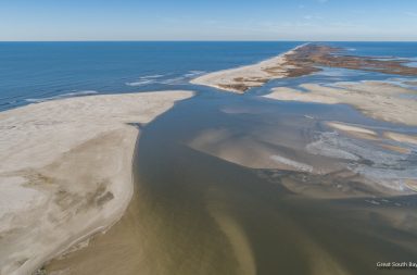
Since then we have had several powerful storms and I could see large deposits of sand forming on the bay side from Smith Point Bridge.
As someone who watched the inlet form and has seen firsthand what it has done for water quality on the Eastern Great South Bay I have always worried that it would close – naturally or by the hand of man.
Just as one storm opened the breach, one storm could potentially close it. I have also been concerned that fresh sand from the recent dredging projects would of course wash off the beaches and end up clogging the inlet.
I took the video above and images below on Sunday 4-2-17 with two things working against me. The bay was extremely cloudy from the big rains on Friday and the tide was running higher than normal. I will need to go back at low tide and after the water clears up to get a better idea what is going on.


More images on page 2.